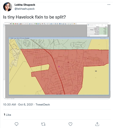
The General Assembly kicked off the map drawing phase of redistricting yesterday. Legislators did little drawing, but we did get to see a bit of Twitter drama when Lekha Shupeck reported that Rep. Destin Hall, chair of the House Redistricting Committee, was splitting the town of Havelock in Craven County:

Shupeck is one of the leaders of the National Democratic Redistricting Committee’s redistricting efforts in North Carolina and presumably understands how redistricting is done here. She missed the mark here, however.
The precinct containing Havelock will be split. There is no way around it.
To understand why you have to consider several factors.
Factor 1: County clusters
When drawing state legislative districts, counties are put into county clusters in which the smallest possible number of districts are placed within the smallest number of counties. Legislators then draw districts within those clusters. Most of the county clusters are determined by geography and county populations; legislators cannot legally alter them.
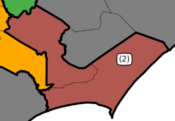
For example, a group of researchers found that Craven and Carteret counties in eastern North Carolina will be grouped together in a two-district NC House cluster (see the detail of their House map below, to which I added county labels). The General Assembly is following their findings, and, as of today, nobody has found any alternate county clusters that would be legal.
Factor 2: County populations
By law, every North Carolina House district must have a population of between 82,645 and 91,345. (If you are doing the math at home, those numbers are plus or minus 5% of the ideal House district population of 86,995. The ideal district population is found by dividing the state’s official population (10,439,388) by the number of House districts (120).)
According to data from the Census Bureau, the official population of Craven County is 110,720, and that of Carteret County is 67,686. That means legislators will have to split off part of Craven County to form a district with Carteret County.
Factor 3: Geography
So, what part of Craven County will join with Carteret County to form an NC House district? The first step is to add whole precincts from Craven to the Carteret-based district. As seen on the official precinct map of Craven County, two precincts are on the extreme southern end of the county, on the border with Carteret: Havelock (which contains the town of Havelock) and Harlowe. Here is a detail of that map with labels added:
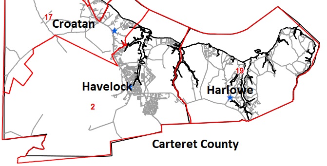
Given its location on the county’s southeastern corner, Harlowe would have to be added to the Carteret-based district first. Harlowe’s population, found on page 12 of the General Assembly’s population by voting district report, is only 3,901. The resulting district population of 71,587 is still well below the minimum allowed population of 82,645. Adding all of Havelock Precinct’s 18,203 population in addition to Harlowe’s 3,901 would reduce the population of the district in Craven County to 78,616 (again, below the legal minimum of 82,645).
Since there are no other Craven County precincts that can be added to the Carteret-based district without going through Havelock, the only way to get both the districts in the Craven-Carteret county cluster within the legally required population range is to split Havelock Precinct.
Havelock is home to Marine Corps Air Station Cherry Point, and nobody wants to be accused of “gerrymandering the Marines.” However, legislators have no choice but to split Havelock and will have to make similar tough choices all over North Carolina.